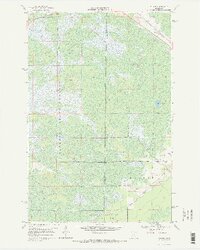
1969 Map of Island
USGS Topo · Published 1972About this map
The vast wetland of Island Swamp dominates this late-1960s landscape along the border of Aitkin and St. Louis counties. This region, characterized by extensive marshes and thick vegetation, is structured by a network of drainage infrastructure like East Judicial Ditch and the Savanna Ditch No 3. These water management features illustrate the historical efforts to modify the Minnesota wilderness for varied land use. To the north, the Burlington Northern railroad cuts across the terrain, serving small points of activity at Island and Hartley Spur. Much of the southern portion is preserved within Savanna State Forest and Savanna Portage State Park, protecting the historical portage route and the natural flow of the Savanna River. Evidence of timber and resource extraction persists through various routes such as Logging Traie and the Headboom Trail.
Find a feature on this map
21 named features on this map. Tap any name to fly to it.
Don’t see what you’re looking for? This feature index may not catch every label — zoom into the map to look around manually.
Map Details
Editions of this 1969 Island Map
2 editions found

Other maps of this area

1953 · Duluth
USGS Topo · 1:250,000

1954 · Hibbing
USGS Topo · 1:250,000

1957 · Hibbing
USGS Topo · 1:250,000

1958 · Hibbing
USGS Topo · 1:250,000

1958 · Duluth
USGS Topo · 1:250,000

1963 · Prairie Lake
USGS Topo · 1:24,000

1963 · Toivola SW
USGS Topo · 1:24,000
1963 · Floodwood
USGS Topo · 1:24,000

1964 · Hibbing
USGS Topo · 1:250,000

1969 · Wawina
USGS Topo · 1:24,000