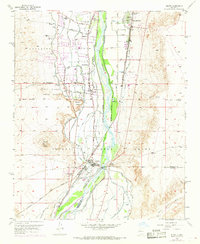
1952 Map of Isleta
USGS Topo · Published 1969About this map
The Rio Grande corridor south of Albuquerque is defined here by an intricate system of water management and ancestral lands. The Isleta Pueblo Indian Land and the Isleta Pueblo Grant dominate the southern half of the map, centering on the historic community of Isleta. Life in this valley is organized around the river's flow, regulated by the Isleta Diversion Dam and an extensive network of irrigation features including the Albuquerque Riverside Drain, Arenal Canal, and Peralta Main Canal.
Find a feature on this map
37 named features on this map. Tap any name to fly to it.
Don’t see what you’re looking for? This feature index may not catch every label — zoom into the map to look around manually.
Map Details
Editions of this 1952 Isleta Map

Other maps of this area

1888 · Bernalillo
USGS Topo · 1:125,000

1889 · Albuquerque
USGS Topo · 1:125,000

1893 · Albuquerque
USGS Topo · 1:125,000

1934 · West Albuquerque
USGS Topo · 1:24,000

1934 · East Albuquerque
USGS Topo · 1:24,000

1938 · Albuquerque
USGS Topo · 1:62,500

1952 · Wind Mesa
USGS Topo · 1:24,000

1952 · Dalies
USGS Topo · 1:24,000

1952 · Hubbell Spring
USGS Topo · 1:24,000

1952 · Los Lunas SE
USGS Topo · 1:24,000