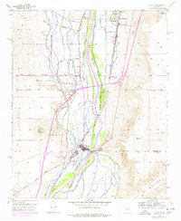
1952 Map of Isleta
USGS Topo · Published 1978About this map
Rio Grande floodplains and volcanic heights define this mid-century portrait of the Middle Rio Grande Valley south of Albuquerque. The landscape is a complex web of agricultural engineering, where the Isleta Diversion Dam feeds a network of historic waterways including the Peralta Main Canal, Pajarito Ditch, and Albuquerque Riverside Drain. These systems supported the agricultural life of Pajarito, Los Padillas, and Isleta Pueblo, while the massive basalt landforms of Black Mesa and Parea Mesa rise sharply to the west. Evidence of deep-rooted community life is visible in the placement of the Old Pajarito Sch, the Mountainview Mission, and several family and community burial grounds such as Los Padillas Cem. The infrastructure of movement is equally prominent, featuring the historic route of El Camino Real and the busy corridor of the Atchison Topeka and Santa Fe railroad, which parallels the river's course through the valley floor.
Find a feature on this map
41 named features on this map. Tap any name to fly to it.
Don’t see what you’re looking for? This feature index may not catch every label — zoom into the map to look around manually.
Map Details
Editions of this 1952 Isleta Map

Other maps of this area

1888 · Bernalillo
USGS Topo · 1:125,000

1889 · Albuquerque
USGS Topo · 1:125,000

1893 · Albuquerque
USGS Topo · 1:125,000

1934 · West Albuquerque
USGS Topo · 1:24,000

1934 · East Albuquerque
USGS Topo · 1:24,000

1938 · Albuquerque
USGS Topo · 1:62,500

1952 · Wind Mesa
USGS Topo · 1:24,000

1952 · Dalies
USGS Topo · 1:24,000

1952 · Hubbell Spring
USGS Topo · 1:24,000

1952 · Los Lunas SE
USGS Topo · 1:24,000