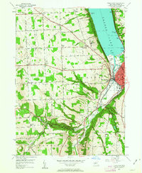
1949 Map of Ithaca West
USGS Topo · Published 1963About this map
Ithaca sits at the southern tip of Cayuga Lake, serving as a regional hub for industry and education just after World War II. The landscape is defined by its dramatic hydrology, featuring the steep descents of Buttermilk Falls and the carved gorge of Enfield Glen. These natural landmarks are preserved within Robert H Treman State Park and Buttermilk Falls State Park, reflecting the era's commitment to public recreation and conservation. Along the eastern shore, the Lehigh Valley railroad and the Delaware Lackawanna and Western lines converge on the city, illustrating the vital rail network that sustained the Finger Lakes region.
Find a feature on this map
65 named features on this map. Tap any name to fly to it.
Don’t see what you’re looking for? This feature index may not catch every label — zoom into the map to look around manually.
Map Details
Editions of this 1949 Ithaca West Map
5 editions found

Other maps of this area

1893 · Ithaca
USGS Topo · 1:62,500

1895 · Ithaca
USGS Topo · 1:62,500

1898 · Moravia
USGS Topo · 1:62,500

1900 · Dryden
USGS Topo · 1:62,500

1902 · Moravia
USGS Topo · 1:62,500

1902 · Genoa
USGS Topo · 1:62,500

1905 · Watkins Glen
USGS Topo · 1:125,000

1906 · Catatonk
USGS Topo · 1:125,000

1942 · Ludlowville
USGS Topo · 1:24,000

1942 · Trumansburg
USGS Topo · 1:24,000