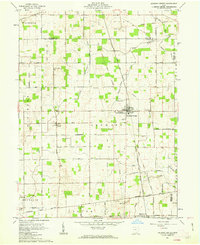
1961 Map of Jackson Center
USGS Topo · Published 1963About this map
The Greenville Treaty Line bisects this agricultural landscape, marking a significant historical boundary between the Congress Lands and the Miami River Survey. The village of Jackson Center serves as the primary hub, situated along the Detroit Toledo and Ironton railroad. This rail line cuts a diagonal path through the terrain, connecting the village to surrounding farming communities like Montra and Maplewood.
Find a feature on this map
51 named features on this map. Tap any name to fly to it.
Don’t see what you’re looking for? This feature index may not catch every label — zoom into the map to look around manually.
Map Details
Editions of this 1961 Jackson Center Map
Other maps of this area

1906 · Lima
USGS Topo · 1:62,500

1913 · Alger
USGS Topo · 1:48,000

1913 · Bellefontaine
USGS Topo · 1:48,000

1913 · Sidney
USGS Topo · 1:62,500

1915 · Alger
USGS Topo · 1:62,500

1915 · Bellefontaine
USGS Topo · 1:62,500

1943 · Alger
USGS Topo · 1:62,500

1944 · Sidney
USGS Topo · 1:62,500

1944 · Bellefontaine
USGS Topo · 1:62,500

1950 · Marion
USGS Topo · 1:250,000