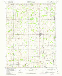
1961 Map of Jackson Center
USGS Topo · Published 1974About this map
Jackson Center sits at the heart of this landscape, its village grid bisected by the Detroit Toledo and Ironton railroad. The surrounding Shelby County terrain is marked by the complex history of early surveying and land agreements, notably defined by the Greenville Treaty Line and the Indian Treaty Boundary, which cut across the north and south. This rural area is anchored by several long-standing spiritual and community centers, including St Lawrence Ch and St Jacobs Ch, alongside several family and community burial grounds such as Elliott Cem and McCord Cem. The hydrology is dominated by small prairie waterways like Little Muchinippi Creek and Tawawa Creek, which drain the agricultural patchwork. Unique local landmarks like the Korn Landing Field and various gravel pits reveal a mid-century economy built on local transport and resource extraction.
Find a feature on this map
43 named features on this map. Tap any name to fly to it.
Don’t see what you’re looking for? This feature index may not catch every label — zoom into the map to look around manually.
Map Details
Editions of this 1961 Jackson Center Map
Other maps of this area

1906 · Lima
USGS Topo · 1:62,500

1913 · Alger
USGS Topo · 1:48,000

1913 · Bellefontaine
USGS Topo · 1:48,000

1913 · Sidney
USGS Topo · 1:62,500

1915 · Alger
USGS Topo · 1:62,500

1915 · Bellefontaine
USGS Topo · 1:62,500

1943 · Alger
USGS Topo · 1:62,500

1944 · Sidney
USGS Topo · 1:62,500

1944 · Bellefontaine
USGS Topo · 1:62,500

1950 · Marion
USGS Topo · 1:250,000