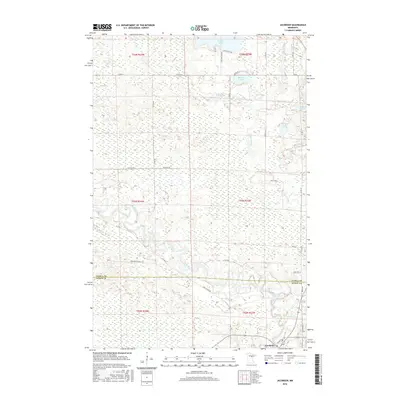
2016 Map of Jacobson
USGS Topo · Published 2016About this map
Jacobson sits at the southern edge of this northern Minnesota landscape, positioned where the Mississippi River winds through the lowlands of the Itasca Co Aitkin Co line. The terrain is defined by the convergence of the Swan River and the Mississippi, creating a complex wetland environment dominated by numerous named water bodies such as Shallow Lake, Austin Lake, and McGuire Lake. The road network provides access to the surrounding forest and lake country via routes like the Great River Rd and Pine Ridge Forest Rd.
Find a feature on this map
34 named features on this map. Tap any name to fly to it.
Don’t see what you’re looking for? This feature index may not catch every label — zoom into the map to look around manually.
Map Details
Editions of this 2016 Jacobson Map
This is the sole edition of this map. No revisions or reprints were ever made.
Other maps of this area

1953 · Duluth
USGS Topo · 1:250,000

1954 · Hibbing
USGS Topo · 1:250,000

1957 · Hibbing
USGS Topo · 1:250,000

1958 · Hibbing
USGS Topo · 1:250,000

1958 · Duluth
USGS Topo · 1:250,000

1964 · Hibbing
USGS Topo · 1:250,000

1969 · La Prairie
USGS Topo · 1:24,000
1969 · Goodland
USGS Topo · 1:24,000
1970 · Warba
USGS Topo · 1:24,000

1970 · Split Hand Lake
USGS Topo · 1:24,000