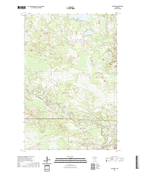
2022 Map of Jacobson
USGS Topo · Published 2022About this map
The Mississippi River meanders through the heart of this landscape, forming a natural boundary near the Itasca Co Aitkin Co line. In the southern reach of the map, the settlement of Jacobson sits at the junction of the river and the Swan River, surrounded by a dense network of local routes including the Rabey Line Trl. This area is characterized by vast wetlands and small water bodies like Shallow Lake and McGuire Lake to the north, near the village of Warba. The drainage patterns here reveal a landscape dominated by the slow-moving waters of the northern Mississippi watershed, where historical forest roads like Pine Ridge Forest Rd and the Great River Rd trace the river's winding course.
Find a feature on this map
33 named features on this map. Tap any name to fly to it.
Don’t see what you’re looking for? This feature index may not catch every label — zoom into the map to look around manually.
Map Details
Editions of this 2022 Jacobson Map
This is the sole edition of this map. No revisions or reprints were ever made.
Other maps of this area

1953 · Duluth
USGS Topo · 1:250,000

1954 · Hibbing
USGS Topo · 1:250,000

1957 · Hibbing
USGS Topo · 1:250,000

1958 · Hibbing
USGS Topo · 1:250,000

1958 · Duluth
USGS Topo · 1:250,000

1964 · Hibbing
USGS Topo · 1:250,000

1969 · La Prairie
USGS Topo · 1:24,000
1969 · Goodland
USGS Topo · 1:24,000
1970 · Warba
USGS Topo · 1:24,000

1970 · Split Hand Lake
USGS Topo · 1:24,000