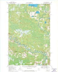
1970 Map of Jacobson
USGS Topo · Published 1972About this map
The Mississippi River winds in deep oxbows through this northern Minnesota landscape, meeting the Swan River just south of the settlement at Jacobson. Surveyed in the late 1960s, the terrain is defined by a vast complex of wetlands and lakes, including Shallow Lake and McGuire Lake, which sit north of the Savanna State Forest boundary. An Old Railroad Grade cuts through the forest south of the county line, providing a physical link to earlier logging or transit routes that once traversed these marshes. The map documents the boundary between Itasca and Aitkin Counties, showing a sparsely populated region where infrastructure is limited to a few primary roads, a Gaging Station on the river, and scattered extraction sites like a Gravel Pit. The map captures the natural drainage patterns of the Sago area before modern development further altered the wilderness character of the upper Mississippi basin.
Find a feature on this map
16 named features on this map. Tap any name to fly to it.
Don’t see what you’re looking for? This feature index may not catch every label — zoom into the map to look around manually.
Map Details
Editions of this 1970 Jacobson Map
This is the sole edition of this map. No revisions or reprints were ever made.
Other maps of this area

1953 · Duluth
USGS Topo · 1:250,000

1954 · Hibbing
USGS Topo · 1:250,000

1957 · Hibbing
USGS Topo · 1:250,000

1958 · Hibbing
USGS Topo · 1:250,000

1958 · Duluth
USGS Topo · 1:250,000

1964 · Hibbing
USGS Topo · 1:250,000

1969 · La Prairie
USGS Topo · 1:24,000
1969 · Goodland
USGS Topo · 1:24,000
1970 · Warba
USGS Topo · 1:24,000

1970 · Split Hand Lake
USGS Topo · 1:24,000