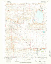
1963 Map of James Lake
USGS Topo · Published 1966About this map
James Lake serves as a central landmark in this high-plains landscape of Albany County, where a complex network of irrigation systems supported the region's mid-century ranching operations. The presence of Battin Ditch, Bellamy Ditch No 1, and Snake Ditch Road highlights the critical role of water management in this environment. Cattle and sheep ranching roots are evident in family-named holdings such as Hunt Ranch, May Ranch, and Miller Ranch situated along the drainage of Sevenmile Creek and the Little Laramie River.
Find a feature on this map
26 named features on this map. Tap any name to fly to it.
Don’t see what you’re looking for? This feature index may not catch every label — zoom into the map to look around manually.
Map Details
Editions of this 1963 James Lake Map
2 editions found
Other maps of this area

1895 · Laramie
USGS Topo · 1:125,000

1902 · Laramie
USGS Topo · 1:125,000

1905 · Laramie
USGS Topo · 1:125,000

1906 · Medicine Bow
USGS Topo · 1:125,000

1906 · Laramie
USGS Topo · 1:125,000

1908 · Laramie
USGS Topo · 1:125,000

1908 · Medicine Bow
USGS Topo · 1:125,000

1954 · Cheyenne
USGS Topo · 1:250,000

1954 · Rawlins
USGS Topo · 1:250,000

1955 · Big Judson
USGS Topo · 1:24,000