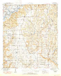
1943 Map of Jay
USGS Topo · Published 1950About this map
Escambia River meanders along the western edge of this 1940s landscape, creating a complex system of backwaters and oxbows such as Ashton Dead River and Campbell Dead River. This survey, conducted just after the United States entered World War II, reveals a rural network of small agricultural settlements and crossroads communities across Santa Rosa County. The map provides significant genealogical value, documenting the specific locations of family-named landmarks like Old Fidelis Cem and Walling Cem, alongside numerous country schools including Greenwood Sch and Chumuckla Sch. The interior is defined by the drainage basins of Juniper Creek and Coldwater Creek, where churches like Cora Ch and the Primitive Baptist Ch served as the primary social hubs for scattered homesteads in the Piney Woods.
Find a feature on this map
77 named features on this map. Tap any name to fly to it.
Don’t see what you’re looking for? This feature index may not catch every label — zoom into the map to look around manually.
Map Details
Editions of this 1943 Jay Map
4 editions found

Other maps of this area

1920 · Milton
USGS Topo · 1:62,500

1921 · Muscogee
USGS Topo · 1:62,500

1934 · Harold
USGS Topo · 1:62,500

1937 · Harold
USGS Topo · 1:62,500

1938 · Harold
USGS Topo · 1:62,500

1941 · Muscogee
USGS Topo · 1:62,500

1941 · Milton
USGS Topo · 1:62,500

1941 · Century
USGS Topo · 1:62,500

1943 · Muscogee
USGS Topo · 1:62,500

1943 · Century
USGS Topo · 1:62,500