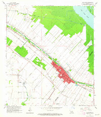
1963 Map of Jeanerette
USGS Topo · Published 1964About this map
Bayou Teche defines the primary corridor of settlement and industry in this portion of Acadiana, with the city of Jeanerette and smaller hamlets like Hubertville and Loisel clustered along its banks. The landscape reflects a dual economy of agriculture and extraction, where extensive drainage networks like the Delahoussaye Canal and Sandager Canal serve the low-lying fields adjacent to the Iberia Oil and Gas Field. Parallel rail lines from the Southern Pacific and Missouri Pacific systems reinforce this transit artery, supporting local commerce and the transport of sugar and oil. Genealogists can locate numerous community landmarks, including Frances Boley School, St Marks Church, and the Boynton Cemetery, which provide a detailed record of the social fabric in the early 1960s. To the northeast, the terrain transitions into the swampy margins of Lake Fausse Pointe, marked by isolated outposts like Bourgeois Landing.
Find a feature on this map
44 named features on this map. Tap any name to fly to it.
Don’t see what you’re looking for? This feature index may not catch every label — zoom into the map to look around manually.
Map Details
Editions of this 1963 Jeanerette Map
2 editions found
Other maps of this area

1937 · Jeanerette
USGS Topo · 1:62,500

1937 · Derouen
USGS Topo · 1:62,500

1939 · St. Martinsville
USGS Topo · 1:62,500

1941 · Loreauville
USGS Topo · 1:62,500

1945 · New Orleans
USGS Topo · 1:250,000

1954 · Loreauville
USGS Topo · 1:62,500

1954 · Jeanerette
USGS Topo · 1:62,500

1954 · Baton Rouge
USGS Topo · 1:250,000

1956 · Baton Rouge
USGS Topo · 1:250,000

1957 · St. Martinville
USGS Topo · 1:62,500