
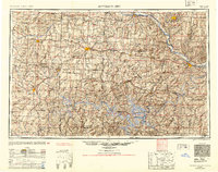
1954 Map of Jefferson City
USGS Topo · Published 1954About this map
The Missouri River carves the northern boundary of this central Missouri landscape, where the state capital of Jefferson City serves as a hub for the region's mid-century river-and-rail commerce. To the west, the major rail junction of Sedalia stands near Sedalia AAF, reflecting the area's strategic transportation importance just after the war. The southern reaches of the map are dominated by the winding fingers of the Lake of the Ozarks, a massive reservoir created by the damming of the Osage River. This survey reveals the transition from the flatter agricultural lands of Pettis County to the more dissected terrain around the Niangua River and Gasconade River. Smaller agricultural communities like Tipton, California, and Versailles are linked by a dense network of roads and the tracks of the Missouri Pacific RR, illustrating the deeply integrated rural economy of the 1950s.
Find a feature on this map
176 named features on this map. Tap any name to fly to it.
Don’t see what you’re looking for? This feature index may not catch every label — zoom into the map to look around manually.
Map Details
Editions of this 1954 Jefferson City Map
2 editions found
Other maps of this area

1884 · Bolivar
USGS Topo · 1:125,000

1885 · Warrensburg
USGS Topo · 1:125,000

1886 · Nevada
USGS Topo · 1:125,000

1886 · Jefferson City
USGS Topo · 1:125,000

1886 · Stockton
USGS Topo · 1:125,000

1887 · Clinton
USGS Topo · 1:125,000

1887 · Harrisonville
USGS Topo · 1:125,000

1887 · Sedalia
USGS Topo · 1:125,000

1887 · Warsaw
USGS Topo · 1:125,000

1887 · Butler
USGS Topo · 1:125,000