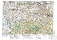
1955 Map of Jefferson City
USGS Topo · Published 1986About this map
The Missouri River winds along the northern edge of this Central Missouri landscape, while the intricate, finger-like reaches of the Lake of the Ozarks dominate the southern portion. This mid-century survey captures a region defined by its diverse transport and institutional hubs, from the strategic operations at Whiteman AFB to the academic grounds of Lincoln Univ and Stephens College. The transition from the river plains near Boonville and Jefferson City to the more broken terrain around Warsaw and Versailles reveals a complex network of Missouri-Kansas-Texas and Missouri Pacific rail lines that once fueled the local economy. In the west, Strip Mines near Clinton point to the area's extraction history, while the State Fairground & Racetrack in Sedalia serves as a prominent cultural landmark for the agricultural heartland.
Find a feature on this map
71 named features on this map. Tap any name to fly to it.
Don’t see what you’re looking for? This feature index may not catch every label — zoom into the map to look around manually.
Map Details
Editions of this 1955 Jefferson City Map
4 editions found

Other maps of this area

1884 · Bolivar
USGS Topo · 1:125,000

1885 · Warrensburg
USGS Topo · 1:125,000

1886 · Nevada
USGS Topo · 1:125,000

1886 · Jefferson City
USGS Topo · 1:125,000

1886 · Stockton
USGS Topo · 1:125,000

1887 · Clinton
USGS Topo · 1:125,000

1887 · Harrisonville
USGS Topo · 1:125,000

1887 · Sedalia
USGS Topo · 1:125,000

1887 · Warsaw
USGS Topo · 1:125,000

1887 · Butler
USGS Topo · 1:125,000