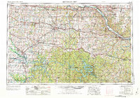
1955 Map of Jefferson City
USGS Topo · Published 1973About this map
The Missouri River corridor serves as the primary artery through this Central Missouri landscape, anchoring a network of towns and infrastructure. In the mid-20th century, the region's economy and geography were defined by the intersection of major rail lines like the Missouri Pacific and Chicago Rock Island and Pacific with emerging military and industrial sites. Whiteman AFB appears as a significant federal footprint between Warrensburg and Sedalia, while the rising waters of the Harry S Truman Reservoir and the established Lake of the Ozarks mark the transition into the southern hill country.
Find a feature on this map
78 named features on this map. Tap any name to fly to it.
Don’t see what you’re looking for? This feature index may not catch every label — zoom into the map to look around manually.
Map Details
Editions of this 1955 Jefferson City Map
4 editions found

Other maps of this area

1884 · Bolivar
USGS Topo · 1:125,000

1885 · Warrensburg
USGS Topo · 1:125,000

1886 · Nevada
USGS Topo · 1:125,000

1886 · Jefferson City
USGS Topo · 1:125,000

1886 · Stockton
USGS Topo · 1:125,000

1887 · Clinton
USGS Topo · 1:125,000

1887 · Harrisonville
USGS Topo · 1:125,000

1887 · Sedalia
USGS Topo · 1:125,000

1887 · Warsaw
USGS Topo · 1:125,000

1887 · Butler
USGS Topo · 1:125,000