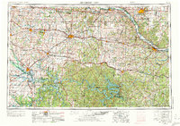
1955 Map of Jefferson City
USGS Topo · Published 1973About this map
The Missouri River corridor and its surrounding uplands dominate this mid-century view, showing the vital waterways and rail networks of Central Missouri. The map illustrates a landscape transitioning from the riverfront state capital at Jefferson City and the educational center of Columbia to the recreational and hydroelectric reaches of the Lake of the Ozarks. Between these hubs, the regional economy is defined by heavy transit and industry, including a massive Strip Mine near Clinton and the strategic presence of Whiteman AFB near Knob Noster.
Find a feature on this map
63 named features on this map. Tap any name to fly to it.
Don’t see what you’re looking for? This feature index may not catch every label — zoom into the map to look around manually.
Map Details
Editions of this 1955 Jefferson City Map
4 editions found

Other maps of this area

1884 · Bolivar
USGS Topo · 1:125,000

1885 · Warrensburg
USGS Topo · 1:125,000

1886 · Nevada
USGS Topo · 1:125,000

1886 · Jefferson City
USGS Topo · 1:125,000

1886 · Stockton
USGS Topo · 1:125,000

1887 · Clinton
USGS Topo · 1:125,000

1887 · Harrisonville
USGS Topo · 1:125,000

1887 · Sedalia
USGS Topo · 1:125,000

1887 · Warsaw
USGS Topo · 1:125,000

1887 · Butler
USGS Topo · 1:125,000