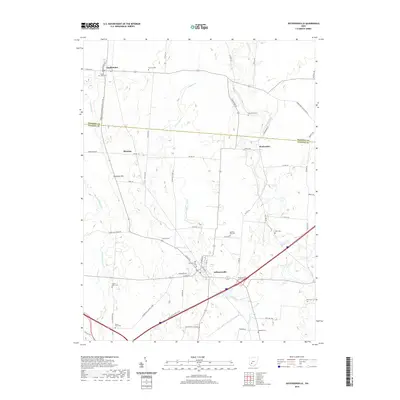
2019 Map of Jeffersonville
USGS Topo · Published 2019About this map
Jeffersonville stands as a central hub in this corner of Fayette County, where the landscape is defined by the headwaters of Sugar Creek and Paint Creek. The map documents a predominantly agricultural region at the border of Madison County, punctuated by small rural clusters such as South Solon, Blessing, and Bookwalter. This 2019 survey is an essential resource for genealogists, as it preserves the locations of numerous family and community burial grounds including Old Jeffersonville Cem, Hidy Cem, and the uniquely named Booco - Ryan Cem. The terrain is characterized by gentle shifts in elevation, most notably at Dumpling Hill north of Jeffersonville. Transportation patterns are clearly established here, from the diagonal path of Interstate 71 to local landmarks like the South Southbound Rest Area, reflecting the continued importance of these corridors to the local economy.
Find a feature on this map
64 named features on this map. Tap any name to fly to it.
Don’t see what you’re looking for? This feature index may not catch every label — zoom into the map to look around manually.
Map Details
Editions of this 2019 Jeffersonville Map
This is the sole edition of this map. No revisions or reprints were ever made.
Other maps of this area

1906 · Mt Sterling
USGS Topo · 1:62,500

1907 · London
USGS Topo · 1:62,500

1907 · South Charleston
USGS Topo · 1:62,500

1916 · Octa
USGS Topo · 1:62,500

1944 · Octa
USGS Topo · 1:62,500

1947 · Columbus
USGS Topo · 1:250,000

1961 · Columbus
USGS Topo · 1:250,000
1961 · Florence
USGS Topo · 1:24,000
1961 · Walnut Run
USGS Topo · 1:24,000
1961 · Milledgeville
USGS Topo · 1:24,000