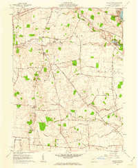
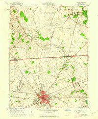
1961 Map of Walnut Run
USGS Topo · Published 1962About this map
The rolling agricultural landscape of Madison County is documented here at the start of the 1960s, defined by its intricate network of drainage ditches and family-named roads. The village of Newport serves as a small hub amidst a terrain crossed by the Pennsylvania railroad and several winding watercourses, including Walnut Run, Oak Run, and Bradford Creek. This survey provides significant genealogical value, identifying numerous small family and community burial grounds such as Kirkwood Cem, Evans Cem, Kilgore Cem, and the Old Johnston Cem. In the northeast, the Madison Lake State Reserve highlights the area's recreational development around Madison Lake. The map also captures educational shifts, labeling both the Old Madison Sch and the Madison High Sch, while local infrastructure is further detailed by an Airstrip and a Radio Tower, reflecting the modernizing rural economy within the historic Virginia Military District.
Find a feature on this map
53 named features on this map. Tap any name to fly to it.
Don’t see what you’re looking for? This feature index may not catch every label — zoom into the map to look around manually.
Map Details
Editions of this 1961 Walnut Run Map
2 editions found
Other maps of this area

1906 · Mt Sterling
USGS Topo · 1:62,500

1907 · London
USGS Topo · 1:62,500

1907 · South Charleston
USGS Topo · 1:62,500

1916 · Octa
USGS Topo · 1:62,500

1944 · Octa
USGS Topo · 1:62,500

1947 · Columbus
USGS Topo · 1:250,000

1961 · Columbus
USGS Topo · 1:250,000
1961 · Vienna
USGS Topo · 1:24,000
1961 · West Jefferson
USGS Topo · 1:24,000
1961 · London
USGS Topo · 1:24,000