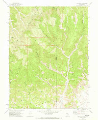
1970 Map of Jim Canyon
USGS Topo · Published 1973About this map
The Book Cliffs dominate the southern landscape of this 1970 survey, where the high desert terrain of the Utah-Colorado border is defined by deep drainage systems like Prairie Canyon and Cottonwood Canyon. This era represents a period of significant energy development in the region, evidenced by the numerous Gas Wells and infrastructure associated with the San Arroyo Gas Field and Overlook Gas Field. The intricate topography of Overlook Ridge and Hells Hole Canyon is accessible primarily via a network of Jeep Trails, highlighting the remote and industrial character of the area during the early 1970s. Historical boundaries are clearly marked, including the intersection of Uintah, Grand, and Garfield counties at the state line, where Bitter Creek and Bar X Wash carve through the sedimentary layers of the plateau.
Find a feature on this map
25 named features on this map. Tap any name to fly to it.
Don’t see what you’re looking for? This feature index may not catch every label — zoom into the map to look around manually.
Map Details
Editions of this 1970 Jim Canyon Map
2 editions found
Other maps of this area

1885 · East Tavaputs
USGS Topo · 1:250,000

1956 · Grand Junction
USGS Topo · 1:250,000

1959 · Grand Junction
USGS Topo · 1:250,000

1960 · Grand Junction
USGS Topo · 1:250,000

1962 · Grand Junction
USGS Topo · 1:250,000

1964 · Grand Junction
USGS Topo · 1:250,000

1964 · Baxter Pass
USGS Topo · 1:24,000

1965 · Grand Junction
USGS Topo · 1:250,000

1966 · Tom Patterson Canyon
USGS Topo · 1:24,000
1966 · Rat Hole Ridge
USGS Topo · 1:24,000