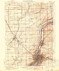
1923 Map of Joliet
USGS Topo · Published 1942About this map
Industrial development and traditional agriculture meet at the convergence of the Des Plaines River and two major man-made waterways. The city of Joliet serves as the focal point for a dense network of railroads, including the Michigan Central RR and the Chicago and Alton RR, supporting the region's manufacturing and shipping economy. Just north of the city, the State Penitentiary Farm occupies a significant tract of land near the Sanitary and Ship Canal.
Find a feature on this map
90 named features on this map. Tap any name to fly to it.
Don’t see what you’re looking for? This feature index may not catch every label — zoom into the map to look around manually.
Map Details
Editions of this 1923 Joliet Map
5 editions found

Other maps of this area

1890 · Des Plaines
USGS Topo · 1:62,500

1891 · Riverside
USGS Topo · 1:62,500

1892 · Morris
USGS Topo · 1:62,500

1892 · Joliet
USGS Topo · 1:62,500

1892 · Wilmington
USGS Topo · 1:62,500

1893 · Riverside
USGS Topo · 1:62,500

1894 · Des Plaines
USGS Topo · 1:62,500

1900 · Des Plaines
USGS Topo · 1:62,500

1900 · Riverside
USGS Topo · 1:62,500

1901 · Des Plaines
USGS Topo · 1:62,500