
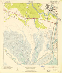
1943 Map of Jones Creek
USGS Topo · Published 1943About this map
Brazos River delta lands and the low-lying coastal marshes of Brazoria County define this mid-century landscape. The area is marked by established community centers like Perry Landing and Jones Creek, which are surrounded by essential local institutions including St Joseph Ch, Peach Point Ch, and the Oakland Sch. To the northwest, the large tract of the Clemens State Farm occupies a significant portion of the inland territory. Near the coast, the burgeoning industrial and maritime presence is evident in the proximity of Freeport and Velasco, where the Velasco Cem and Bell Cem serve as quiet records of early settlement. The southern half of the map is dominated by a complex network of bayous and lakes, including McNeal Lake, Pelican Lake, and Red Fish Bayou, all positioned north of the Intracoastal Waterway and the open waters of the Gulf of Mexico.
Find a feature on this map
31 named features on this map. Tap any name to fly to it.
Don’t see what you’re looking for? This feature index may not catch every label — zoom into the map to look around manually.
Map Details
Editions of this 1943 Jones Creek Map
2 editions found
Other maps of this area

1943 · Oyster Creek
USGS Topo · 1:31,680

1943 · Freeport
USGS Topo · 1:31,680

1943 · Cedar Lakes East
USGS Topo · 1:24,000

1943 · Snipe
USGS Topo · 1:31,680

1950 · Houston
USGS Topo · 1:250,000

1951 · Bay City
USGS Topo · 1:250,000

1952 · Cedar Lane NE
USGS Topo · 1:24,000

1952 · Cedar Lakes West
USGS Topo · 1:24,000

1952 · Brazoria
USGS Topo · 1:24,000

1956 · Houston
USGS Topo · 1:250,000