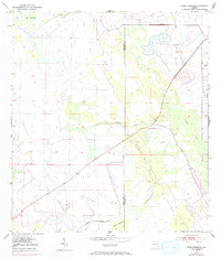
1953 Map of Jones Hammock
USGS Topo · Published 1993About this map
Dark Hammock and the broad wetlands of the Florida interior dominate this mid-century topographic survey, where the boundary between Okeechobee and St. Lucie counties cuts through a landscape of palmetto scrub and cypress strands. The area shows the characteristic drainage patterns of the region, defined by the winding course of Cypress Creek and the southern flow of Nubbin Slough. Human activity is sparse, marked primarily by a Landing Field in the north and various private tracks crossing the marshy terrain.
Find a feature on this map
8 named features on this map. Tap any name to fly to it.
Don’t see what you’re looking for? This feature index may not catch every label — zoom into the map to look around manually.
Map Details
Editions of this 1953 Jones Hammock Map
4 editions found
Other maps of this area

1952 · Okeechobee
USGS Topo · 1:24,000

1953 · Okeechobee 1 SE
USGS Topo · 1:24,000

1953 · Okeechobee 4 NE
USGS Topo · 1:24,000

1953 · Okeechobee 4 NW
USGS Topo · 1:24,000

1953 · Okeechobee 1 SW
USGS Topo · 1:24,000

1953 · Taylor Creek SE
USGS Topo · 1:24,000

1953 · Taylor Creek NE
USGS Topo · 1:24,000

1953 · Okeechobee 1 NE
USGS Topo · 1:24,000

1953 · Okeechobee 1 NW
USGS Topo · 1:24,000

1956 · Fort Pierce
USGS Topo · 1:250,000