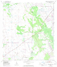
1953 Map of Okeechobee 1 SW
USGS Topo · Published 1971About this map
Negro Jim Scrub and the dense wetlands of central Florida dominate this mid-century landscape, capturing a moment of transition as infrastructure began to alter the natural drainage patterns. The survey, based on 1950s data with later revisions, shows the intricate network of water and terrain including Cypress Creek and the meandering Nubbin Slough in the south. These features are flanked by named landmarks like Dark Hammock and Jones Hammock, which signify slightly elevated, wooded areas amidst the wetter surroundings. The map reveals the early engineering of the region through the presence of a Levee and a Spoil Bank, marking the intersection of the Okeechobee and St. Lucie county line. This document is a primary record for understanding the original hydrography before modern development further reshaped the Florida interior.
Find a feature on this map
9 named features on this map. Tap any name to fly to it.
Don’t see what you’re looking for? This feature index may not catch every label — zoom into the map to look around manually.
Map Details
Editions of this 1953 Okeechobee 1 SW Map
4 editions found
Other maps of this area

1952 · Okeechobee
USGS Topo · 1:24,000

1953 · Okeechobee 1 SE
USGS Topo · 1:24,000

1953 · Okeechobee 4 NE
USGS Topo · 1:24,000

1953 · Okeechobee 4 NW
USGS Topo · 1:24,000

1953 · Okeechobee 1 SW
USGS Topo · 1:24,000

1953 · Taylor Creek SE
USGS Topo · 1:24,000

1953 · Taylor Creek NE
USGS Topo · 1:24,000

1953 · Okeechobee 1 NE
USGS Topo · 1:24,000

1953 · Okeechobee 1 NW
USGS Topo · 1:24,000

1956 · Fort Pierce
USGS Topo · 1:250,000