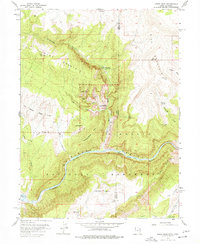
1955 Map of Jones Hole
USGS Topo · Published 1977About this map
Dinosaur National Monument encompasses the centerpiece of this mid-century survey, where the Green River carves a deep path through the plateau. The landscape is defined by massive uplifted blocks, notably Diamond Mountain and Wild Mountain, separated by deep drainages like Diamond Gulch and Jones Hole Creek. The map records essential infrastructure for park management and local ranching during the 1950s, including the Jones Hole Ranger Station and scattered operations such as Snow Ranch and Chew Ranch.
Find a feature on this map
79 named features on this map. Tap any name to fly to it.
Don’t see what you’re looking for? This feature index may not catch every label — zoom into the map to look around manually.
Map Details
Editions of this 1955 Jones Hole Map
4 editions found

Other maps of this area

1885 · Ashley
USGS Topo · 1:250,000

1907 · Rangely
USGS Topo · 1:125,000

1907 · Jensen
USGS Topo · 1:125,000

1910 · Jensen
USGS Topo · 1:125,000

1910 · Rangely
USGS Topo · 1:125,000

1954 · Hells Canyon
USGS Topo · 1:24,000

1954 · Canyon of Lodore South
USGS Topo · 1:24,000

1954 · Canyon of Lodore North
USGS Topo · 1:24,000

1954 · Vernal
USGS Topo · 1:250,000

1955 · Island Park
USGS Topo · 1:24,000