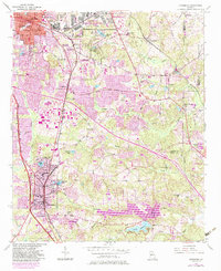
1954 Map of Jonesboro
USGS Topo · Published 1983About this map
Fort Gillem US Military Reservation anchors the northern portion of this Clayton County landscape, illustrating the significant military presence south of Atlanta during the mid-20th century. The transition from rural agricultural land to suburban development is evident as the South Expressway cuts through the terrain, connecting established centers like Jonesboro and Morrow. This 1954 survey, updated with 1980s photorevisions, captures a complex network of local landmarks, from the industrial Sewage Disposal sites to community gathering points like Travis Ch and Mathiamar Ch. Large water bodies such as Lake Spivey and Lake Tara define the recreational and residential character of the area, while the Central of Georgia and Southern railroads trace the historic corridors of commerce that built these Georgia towns.
Find a feature on this map
59 named features on this map. Tap any name to fly to it.
Don’t see what you’re looking for? This feature index may not catch every label — zoom into the map to look around manually.
Map Details
Editions of this 1954 Jonesboro Map
5 editions found
Other maps of this area

1888 · Atlanta
USGS Topo · 1:125,000

1890 · Atlanta
USGS Topo · 1:125,000

1892 · Atlanta
USGS Topo · 1:125,000

1895 · Atlanta
USGS Topo · 1:125,000

1953 · Atlanta
USGS Topo · 1:250,000

1954 · Conley
USGS Topo · 1:24,000

1954 · Jonesboro
USGS Topo · 1:24,000

1954 · Riverdale
USGS Topo · 1:24,000

1954 · East Point
USGS Topo · 1:24,000

1956 · Redan
USGS Topo · 1:24,000