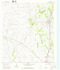
1961 Map of Joshua
USGS Topo · Published 1979About this map
Caddo Peak and Brushy Knob rise above the north Texas prairie in this detailed topographical study, documenting a landscape at the intersection of agriculture and expanding infrastructure. The Atchison Topeka and Santa Fe railroad serves as the primary corridor, connecting the northern settlement of Joshua to the northern edge of Cleburne in the south. This era shows the proliferation of gravel extraction, with numerous Gravel Pits and a Pumping Sta scattered across the drainage basins of the Nolan River and West Buffalo Creek.
Find a feature on this map
28 named features on this map. Tap any name to fly to it.
Don’t see what you’re looking for? This feature index may not catch every label — zoom into the map to look around manually.
Map Details
Editions of this 1961 Joshua Map
Other maps of this area

1889 · Granbury
USGS Topo · 1:125,000

1891 · Weatherford
USGS Topo · 1:125,000

1891 · Cleburne
USGS Topo · 1:125,000

1893 · Weatherford
USGS Topo · 1:125,000

1894 · Cleburne
USGS Topo · 1:125,000

1894 · Fort Worth
USGS Topo · 1:125,000

1928 · Godley
USGS Topo · 1:62,500

1954 · Dallas
USGS Topo · 1:250,000

1955 · Burleson
USGS Topo · 1:24,000

1955 · Primrose
USGS Topo · 1:24,000