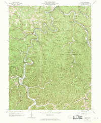
1962 Map of Julian
USGS Topo · Published 1970About this map
The Little Coal River and its larger counterpart, the Coal River, dictate the movement of people and industry through these steep West Virginia hills. In the early 1960s, the Chesapeake and Ohio railroad corridor followed the narrow river valleys, connecting small coal-country outposts like Julian and Horse Creek Junction. The landscape is a network of named hollows and branches, such as Pigeonroost Branch and Nancy Dolin Branch, which provide the only level ground for homesteads and cemeteries like Pate Cem. At Pinnacle Rock, the railroad pierces the ridge through the Pinnacle Tunnel, illustrating the engineering required to navigate this terrain. Social life is centered on landmarks like McCorkle Sch and the Morning Star Ch, while much of the eastern portion of the sheet is dedicated to the Fork Creek State Public Hunting Area.
Find a feature on this map
75 named features on this map. Tap any name to fly to it.
Don’t see what you’re looking for? This feature index may not catch every label — zoom into the map to look around manually.
Map Details
Editions of this 1962 Julian Map
4 editions found
Other maps of this area

1899 · Charleston
USGS Topo · 1:125,000

1909 · Charleston
USGS Topo · 1:62,500

1909 · Peytona
USGS Topo · 1:48,000

1909 · Saint Albans
USGS Topo · 1:62,500

1911 · Peytona
USGS Topo · 1:62,500

1911 · Madison
USGS Topo · 1:62,500

1929 · Madison
USGS Topo · 1:62,500

1929 · Peytona
USGS Topo · 1:62,500

1931 · Madison
USGS Topo · 1:62,500

1931 · Saint Albans
USGS Topo · 1:62,500