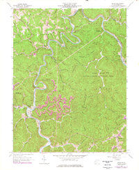
1962 Map of Julian
USGS Topo · Published 1977About this map
The Little Coal River and Big Coal River anchor this topographic survey of the West Virginia coalfields where Boone, Kanawha, and Lincoln counties meet. The landscape is defined by the industrial and transport infrastructure of the mid-20th century, notably the Chesapeake and Ohio railroad lines that follow the river bends to service small communities like Julian, McCorkle, and Brounland. The map reveals the intricate human geography of the hollows, documenting numerous small mountain churches such as Pine Grove Ch and Morning Star Ch, alongside landmarks like the Blue Tom Tunnel and Pinnacle Tunnel. Extensive purple revisions from the 1970s highlight the expansion of surface mining, including a Strip Mine and Mine Dump, reflecting the region's evolving extractive economy alongside the Fork Creek State Public Hunting Area.
Find a feature on this map
79 named features on this map. Tap any name to fly to it.
Don’t see what you’re looking for? This feature index may not catch every label — zoom into the map to look around manually.
Map Details
Editions of this 1962 Julian Map
4 editions found
Other maps of this area

1899 · Charleston
USGS Topo · 1:125,000

1909 · Charleston
USGS Topo · 1:62,500

1909 · Peytona
USGS Topo · 1:48,000

1909 · Saint Albans
USGS Topo · 1:62,500

1911 · Peytona
USGS Topo · 1:62,500

1911 · Madison
USGS Topo · 1:62,500

1929 · Madison
USGS Topo · 1:62,500

1929 · Peytona
USGS Topo · 1:62,500

1931 · Madison
USGS Topo · 1:62,500

1931 · Saint Albans
USGS Topo · 1:62,500