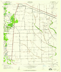
1943 Map of Juliff
USGS Topo · Published 1959About this map
Darrington State Prison Farm anchors the lower portion of this Brazoria County landscape, reflecting the agricultural and institutional character of the region during the early 1940s. The area is defined by the winding course of Oyster Creek and the intricate drainage of Chocolate Bayou, supporting a rural economy that relied on the Briscoe Canal and numerous lakes such as Thompson Lake and Brushy Lake. The map details a network of small settlements and community centers, including Juliff, Iowa Colony, and Sandy Point. Social and educational life is marked by several local institutions, from Mustang Sch to St Phillip Ch. The presence of the Airway Beacon and multiple Oil Wells signals the mid-century modernization of the Texas Gulf Coast, while the Gulf Colorado and Santa Fe railroad provides the vital transit link through these prairie lands.
Find a feature on this map
37 named features on this map. Tap any name to fly to it.
Don’t see what you’re looking for? This feature index may not catch every label — zoom into the map to look around manually.
Map Details
Editions of this 1943 Juliff Map
2 editions found
Other maps of this area

1920 · Mykawa
USGS Topo · 1:31,680

1920 · Almeda
USGS Topo · 1:31,680

1943 · Rosharon
USGS Topo · 1:31,680

1943 · Juliff
USGS Topo · 1:31,680

1943 · Chocolate Bayou
USGS Topo · 1:24,000

1950 · Houston
USGS Topo · 1:250,000

1953 · Otey
USGS Topo · 1:24,000

1953 · Thompsons
USGS Topo · 1:24,000
1955 · Pearland
USGS Topo · 1:24,000
1955 · Almeda
USGS Topo · 1:24,000