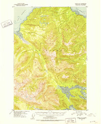
1951 Map of Juneau A-6
USGS Topo · Published 1952About this map
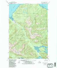
Chichagof Island forms the primary landscape of this 1951 survey, situated within the bounds of the Tongass National Forest. The map documents a rugged coastal environment dominated by deep-water inlets and bights, such as the prominent Neka Bay and its southern and northern reaches at South Bight and North Bight. Settlement is virtually non-existent in this era, marked only by an isolated Cabin situated along the northern shoreline of Neka Bay. To the north, the waters of Icy Strait and Mud Bay define the land's edge, while Tenakee Inlet marks the southern boundary. The intricate contour lines reveal the interior's steep elevations, where drainage systems like Humpback Creek carve through the island's interior towards the coast. This representation of the Alaska panhandle captures the region's character as it was known in the early fifties, prior to significant modern development or shifts in shoreline topography.
Find a feature on this map
11 named features on this map. Tap any name to fly to it.
Don’t see what you’re looking for? This feature index may not catch every label — zoom into the map to look around manually.
Map Details
Editions of this 1951 Juneau A-6 Map
6 editions found
Other maps of this area

1948 · Juneau B-6
USGS Topo · 1:63,360

1948 · Juneau B-5
USGS Topo · 1:63,360

1948 · Sitka D-5
USGS Topo · 1:63,360

1948 · Mount Fairweather B-1
USGS Topo · 1:63,360

1948 · Sitka D-6
USGS Topo · 1:63,360

1948 · Mount Fairweather A-1
USGS Topo · 1:63,360

1950 · Juneau B-5
USGS Topo · 1:63,360

1951 · Juneau
USGS Topo · 1:250,000

1951 · Juneau A-6
USGS Topo · 1:63,360

1951 · Juneau A-5
USGS Topo · 1:63,360