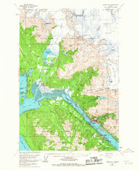
1962 Map of Juneau B-2
USGS Topo · Published 1967About this map
Juneau and the surrounding gold-mining districts are shown here during a period of mid-century infrastructure growth, prior to the city's 1970 unification with its neighbor across the Gastineau Channel. On the mainland, the capital city's original townsite is detailed alongside the Juneau Airport and the developing residential area of Mendenhaven. The industrial legacy of the region is evident in landmarks like The Glory Hole and the site of the historic Treadwell mine on Douglas Island, where the town of Douglas and West Juneau serve as the primary settlements.
Find a feature on this map
86 named features on this map. Tap any name to fly to it.
Don’t see what you’re looking for? This feature index may not catch every label — zoom into the map to look around manually.
Map Details
Editions of this 1962 Juneau B-2 Map
4 editions found

Other maps of this area

1947 · Juneau B-3
USGS Topo · 1:63,360

1947 · Juneau B-2
USGS Topo · 1:63,360

1948 · Juneau A-3
USGS Topo · 1:63,360

1948 · Juneau B-1
USGS Topo · 1:63,360

1949 · Juneau B-3
USGS Topo · 1:62,500

1949 · Juneau B-2
USGS Topo · 1:62,500

1950 · Juneau A-3
USGS Topo · 1:63,360

1951 · Juneau
USGS Topo · 1:250,000

1951 · Juneau A-2
USGS Topo · 1:63,360

1951 · Juneau A-1
USGS Topo · 1:63,360