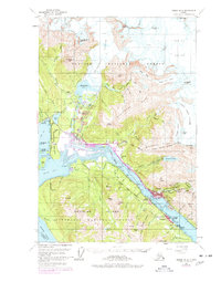
1962 Map of Juneau B-2
USGS Topo · Published 1978About this map
Juneau and the neighboring community of Douglas anchor this 1962 topographic record, which captures the capital city during a period of significant post-war infrastructure expansion. The landscape is defined by the proximity of the Mendenhall Glacier and the Gastineau Channel, illustrating the tight constraints of Alaskan maritime geography. Notable industrial and transportation elements include the Juneau Airport on the tidal flats and the Elevated Tramway leading toward the mountain slopes.
Find a feature on this map
112 named features on this map. Tap any name to fly to it.
Don’t see what you’re looking for? This feature index may not catch every label — zoom into the map to look around manually.
Map Details
Editions of this 1962 Juneau B-2 Map
4 editions found

Other maps of this area

1947 · Juneau B-3
USGS Topo · 1:63,360

1947 · Juneau B-2
USGS Topo · 1:63,360

1948 · Juneau A-3
USGS Topo · 1:63,360

1948 · Juneau B-1
USGS Topo · 1:63,360

1949 · Juneau B-3
USGS Topo · 1:62,500

1949 · Juneau B-2
USGS Topo · 1:62,500

1950 · Juneau A-3
USGS Topo · 1:63,360

1951 · Juneau
USGS Topo · 1:250,000

1951 · Juneau A-2
USGS Topo · 1:63,360

1951 · Juneau A-1
USGS Topo · 1:63,360