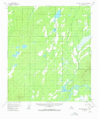
1953 Map of Kantishna River A-3
USGS Topo · Published 1980About this map
The Kantishna River winds through this interior Alaskan landscape, defining the hydrology of a region dominated by interconnected waterways and significant elevation markers. Surveyed in the early 1950s, the map reveals a wilderness structured by the John Hansen Creek system, which feeds into John Hansen Lake before joining the main river channel. The topographic detail captures the rising slopes of Bearpaw Mountain in the southeast, providing a vertical contrast to the extensive marshlands and smaller water bodies like Square Lake and Jeannes Lake that dot the lowland flats. A primary geodetic reference point, VABM Roosevelt 1947, is located in the southwestern corner, serving as a critical anchor for the 1952 photogrammetric mapping efforts. This survey represents the area as it existed before modern development, showing no established roads or trails in this remote portion of the Yukon-Koyukuk region.
Find a feature on this map
7 named features on this map. Tap any name to fly to it.
Don’t see what you’re looking for? This feature index may not catch every label — zoom into the map to look around manually.
Map Details
Editions of this 1953 Kantishna River A-3 Map
3 editions found

Other maps of this area

1948 · Kantishna River
USGS Topo · 1:250,000

1951 · Kantishna River
USGS Topo · 1:250,000

1952 · Mount McKinley
USGS Topo · 1:250,000

1952 · Kantishna River A-3
USGS Topo · 1:63,360

1952 · Kantishna River
USGS Topo · 1:250,000

1952 · Kantishna River A-2
USGS Topo · 1:63,360

1952 · Mount McKinley D-3
USGS Topo · 1:63,360

1953 · Kantishna River B-2
USGS Topo · 1:63,360

1953 · Kantishna River B-4
USGS Topo · 1:63,360

1953 · Kantishna River A-4
USGS Topo · 1:63,360