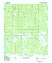
1952 Map of Kantishna River B-6
USGS Topo · Published 1986About this map
The Nowitna National Wildlife Refuge dominates the northwestern portion of this interior landscape, marking a vast transition of protected wilderness where the Kateel River Meridian meets the Fairbanks boundary. This 1952 photogrammetric survey captures the intricate, meandering hydrology of the Titna River and the Sethkokna River before they converge, illustrating a complex network of wetlands and oxbows. The lack of roads or established settlements on this sheet emphasizes the remote character of the Tanana Valley region during the mid-twentieth century. Near the southern edge, Baker Creek drains through the lowlands, while the Chitanana River cuts through the northeast corner, providing a clear record of the area's natural drainage patterns and unsurveyed land lines as established by the Bureau of Land Management.
Find a feature on this map
8 named features on this map. Tap any name to fly to it.
Don’t see what you’re looking for? This feature index may not catch every label — zoom into the map to look around manually.
Map Details
Editions of this 1952 Kantishna River B-6 Map
2 editions found
Other maps of this area

1948 · Kantishna River
USGS Topo · 1:250,000

1951 · Kantishna River
USGS Topo · 1:250,000

1951 · Ruby
USGS Topo · 1:250,000

1952 · Kantishna River C-5
USGS Topo · 1:63,360

1952 · Ruby B-1
USGS Topo · 1:63,360

1952 · Ruby A-1
USGS Topo · 1:63,360

1952 · Ruby C-1
USGS Topo · 1:63,360

1952 · Kantishna River C-6
USGS Topo · 1:63,360

1952 · Kantishna River
USGS Topo · 1:250,000

1952 · Kantishna River B-6
USGS Topo · 1:63,360