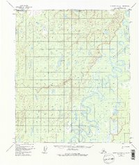
1952 Map of Kantishna River C-1
USGS Topo · Published 1976About this map
The Kantishna River meanders through this interior Alaskan landscape, creating a complex network of oxbow lakes and side channels. Surveyed in the early 1950s using photogrammetric methods, the terrain is defined by its water-rich lowlands, where Geskakmina Lake and Kindanina Lake sit among numerous unnamed ponds and wetlands. The intricate path of the river, with its frequent bends and historical shifts, suggests a highly dynamic fluvial environment where land and water constantly trade places.
Find a feature on this map
6 named features on this map. Tap any name to fly to it.
Don’t see what you’re looking for? This feature index may not catch every label — zoom into the map to look around manually.
Map Details
Editions of this 1952 Kantishna River C-1 Map
3 editions found
Other maps of this area

1948 · Kantishna River
USGS Topo · 1:250,000

1950 · Fairbanks
USGS Topo · 1:250,000

1951 · Kantishna River
USGS Topo · 1:250,000

1951 · Fairbanks
USGS Topo · 1:250,000

1952 · Kantishna River C-1
USGS Topo · 1:63,360

1952 · Kantishna River
USGS Topo · 1:250,000

1952 · Kantishna River B-1
USGS Topo · 1:63,360

1952 · Fairbanks
USGS Topo · 1:250,000

1952 · Kantishna River D-2
USGS Topo · 1:63,360
1952 · Fairbanks D-6
USGS Topo · 1:63,360