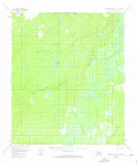
1952 Map of Kantishna River C-1
USGS Topo · Published 1976About this map
The Kantishna River snakes through this low-lying Interior Alaska landscape, its path defined by tight meander loops and countless oxbow lakes. Photographed from the air in the early 1950s, the terrain reveals a vast network of water bodies, including the prominent Geskakmina Lake and Kindamina Lake to the west, and Iksgiza Lake in the north. The presence of Dry Creek suggests the seasonal nature of smaller drainage systems in this subarctic environment. This sheet focuses on the natural hydrology of the Yukon-Koyukuk region, capturing the intricate riverine patterns and wetlands before later environmental shifts or major modern changes. The lack of named roads or settlements highlights the isolation of this corridor, where the river served as the primary natural artery.
Find a feature on this map
5 named features on this map. Tap any name to fly to it.
Don’t see what you’re looking for? This feature index may not catch every label — zoom into the map to look around manually.
Map Details
Editions of this 1952 Kantishna River C-1 Map
3 editions found
Other maps of this area

1948 · Kantishna River
USGS Topo · 1:250,000

1950 · Fairbanks
USGS Topo · 1:250,000

1951 · Kantishna River
USGS Topo · 1:250,000

1951 · Fairbanks
USGS Topo · 1:250,000

1952 · Kantishna River C-1
USGS Topo · 1:63,360

1952 · Kantishna River
USGS Topo · 1:250,000

1952 · Kantishna River B-1
USGS Topo · 1:63,360

1952 · Fairbanks
USGS Topo · 1:250,000

1952 · Kantishna River D-2
USGS Topo · 1:63,360
1952 · Fairbanks D-6
USGS Topo · 1:63,360