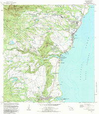
1983 Map of Kapaa
USGS Topo · Published 1984About this map
Poliahu Heiau and the Hauola City of Refuge stand as significant cultural landmarks along the eastern coast of Kauai, where the Wailua River meets Wailua Bay. This early 1980s coastal survey captures a landscape defined by its deep agricultural and spiritual heritage, featuring numerous sacred sites like Malae Heiau and Hikina o ka la Heiau. The settlement patterns of Kapaa and Waipouli are shown alongside extensive inland water management systems, including the Lower Kapahi Res and Wailua Reservoir. The topography is dominated by the ridge known as Sleeping Giant, which overlooks the Wailua House Lots and the Kapaa Homesteads. Further south, the map details the infrastructure around Hanamaulu, including the Ahukini Landing and the Kauai Memorial Gardens, illustrating the transition from agricultural tracts to coastal residential and recreational zones.
Find a feature on this map
86 named features on this map. Tap any name to fly to it.
Don’t see what you’re looking for? This feature index may not catch every label — zoom into the map to look around manually.
Map Details
Editions of this 1983 Kapaa Map
2 editions found
Other maps of this area

1954 · Kauai
USGS Topo · 1:250,000

1963 · Anahola
USGS Topo · 1:24,000

1963 · Lihue
USGS Topo · 1:24,000

1963 · Kapaa
USGS Topo · 1:24,000

1963 · Koloa
USGS Topo · 1:24,000

1963 · Hanalei
USGS Topo · 1:24,000

1965 · Waialeale
USGS Topo · 1:24,000

1967 · Kauai
USGS Topo · 1:250,000

1970 · Kauai
USGS Topo · 1:250,000

1978 · Kapaa
USGS Topo · 1:24,000