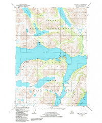
1952 Map of Karluk A-1
USGS Topo · Published 1984About this map
Kodiak National Wildlife Refuge dominates this coastal landscape, protecting a complex network of freshwater lakes and saltwater inlets on the southern portion of Kodiak Island. The maritime infrastructure of the early 1950s is evident at the Cannery on Cannery Cove, which is supported by a nearby Seaplane Base and Gaging Sta on Akalura Cr. This area relies heavily on water-based transportation and seasonal industry, with the rugged topography of Stintz Bluffs and Luchek Mountain rising sharply from the shores of Olga Bay.
Find a feature on this map
28 named features on this map. Tap any name to fly to it.
Don’t see what you’re looking for? This feature index may not catch every label — zoom into the map to look around manually.
Map Details
Editions of this 1952 Karluk A-1 Map
3 editions found

Other maps of this area

1951 · Kaguyak
USGS Topo · 1:250,000

1951 · Trinity Islands
USGS Topo · 1:250,000

1951 · Karluk
USGS Topo · 1:250,000

1952 · Kodiak
USGS Topo · 1:250,000

1952 · Kaguyak
USGS Topo · 1:250,000

1952 · Karluk
USGS Topo · 1:250,000

1952 · Trinity Islands D-2
USGS Topo · 1:63,360

1952 · Karluk B-2
USGS Topo · 1:63,360

1952 · Kodiak B-6
USGS Topo · 1:63,360

1952 · Karluk B-1
USGS Topo · 1:63,360