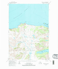
1952 Map of Karluk C-1
USGS Topo · Published 1967About this map
Kodiak National Wildlife Refuge dominates the interior of this coastal sheet, revealing the protected wilderness of southwestern Kodiak Island as it was mapped in the early 1950s. The landscape is defined by the winding course of the Karluk River and the stark northern shoreline of Shelikof Strait. Human presence is minimal, marked by scattered Cabin sites and a single Tractor Trail cutting through the refuge toward the southern waters of Larsen Bay.
Find a feature on this map
22 named features on this map. Tap any name to fly to it.
Don’t see what you’re looking for? This feature index may not catch every label — zoom into the map to look around manually.
Map Details
Editions of this 1952 Karluk C-1 Map
2 editions found
Other maps of this area

1951 · Karluk
USGS Topo · 1:250,000

1951 · Kodiak D-6
USGS Topo · 1:63,360

1952 · Kodiak
USGS Topo · 1:250,000

1952 · Karluk
USGS Topo · 1:250,000

1952 · Karluk C-2
USGS Topo · 1:63,360

1952 · Karluk B-2
USGS Topo · 1:63,360

1952 · Kodiak B-6
USGS Topo · 1:63,360

1952 · Karluk B-1
USGS Topo · 1:63,360

1952 · Karluk C-1
USGS Topo · 1:63,360

1952 · Kodiak C-6
USGS Topo · 1:63,360