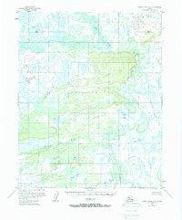
1955 Map of Kateel River D-2
USGS Topo · Published 1963About this map
The Huslia River and its intricate drainage system dominate this mid-century Alaskan interior landscape, characterized by a complex network of meandering sloughs and wetlands. Mapped primarily from aerial photography taken in the early 1950s, the terrain reveals the natural hydrologic patterns of the Kateel River Meridian before significant modern development. The southern portion of the sheet is defined by the broad curves of the Nulitna River and the prominent Nuna Slough, which weave through a low-lying basin dotted with named water bodies such as Evan Lake and Clay Lake. These features, along with the Tom Cook Slough, suggest a landscape shaped by seasonal shifts and traditional river travel. In the north, the convergence of the North Fork and South Fork emphasizes the importance of these waterways as the primary landmarks in an area without established roads or settlements at the time of the survey.
Find a feature on this map
11 named features on this map. Tap any name to fly to it.
Don’t see what you’re looking for? This feature index may not catch every label — zoom into the map to look around manually.
Map Details
Editions of this 1955 Kateel River D-2 Map
3 editions found
Other maps of this area

1951 · Shungnak
USGS Topo · 1:250,000

1951 · Kateel River
USGS Topo · 1:250,000

1954 · Kateel River C-2
USGS Topo · 1:63,360

1954 · Kateel River C-1
USGS Topo · 1:63,360

1954 · Kateel River D-1
USGS Topo · 1:63,360

1954 · Kateel River C-3
USGS Topo · 1:63,360

1954 · Kateel River D-3
USGS Topo · 1:63,360

1955 · Shungnak
USGS Topo · 1:250,000

1955 · Kateel River D-2
USGS Topo · 1:63,360

1955 · Kateel River
USGS Topo · 1:250,000