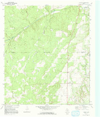
1970 Map of Katemcy
USGS Topo · Published 1991About this map
The San Saba River meanders across the northern reaches of this Hill Country landscape, defining a terrain shaped by winding waterways and cattle ranching. Small ranching communities like Camp San Saba and Katemcy serve as central points for the surrounding rural homesteads, while Camp Air sits further south near the banks of Katemcy Creek. The map documents a sparse but deliberate settlement pattern, where every reliable water source and crossing is named, including the San Saba Ford and numerous spring-fed branches.
Find a feature on this map
32 named features on this map. Tap any name to fly to it.
Don’t see what you’re looking for? This feature index may not catch every label — zoom into the map to look around manually.
Map Details
Editions of this 1970 Katemcy Map
2 editions found
Other maps of this area

1887 · Mason
USGS Topo · 1:125,000

1894 · Brady
USGS Topo · 1:125,000

1894 · Mason
USGS Topo · 1:125,000

1954 · Brownwood
USGS Topo · 1:250,000

1954 · Llano
USGS Topo · 1:250,000

1955 · Llano
USGS Topo · 1:250,000

1956 · Llano
USGS Topo · 1:250,000

1962 · Purdy Hill
USGS Topo · 1:24,000

1963 · Spy Rock
USGS Topo · 1:24,000
1963 · Voca
USGS Topo · 1:24,000