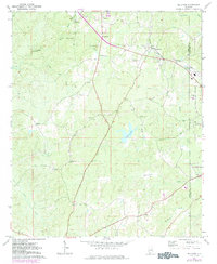
1971 Map of Kellyton
USGS Topo · Published 1984About this map
Kellyton serves as the central hub of this northern Coosa County landscape, situated along the Central of Georgia railroad line. The map reveals a rural economy defined by small communities like Bradford, Keyno, and Ray, connected by a network of creeks including Socapatoy Creek and Elkahatchee Creek. Genealogists will find significant value in the documentation of several family and church burial grounds, such as Chapman Cem, Maxwell Cem, and the Jordan Cem near the shores of Jordan Lake. The presence of several country churches, including Shiloh Ch and Bradford Ch, alongside infrastructure like a pipeline and a local substation, highlights the gradual modernization of these Alabamian woodlands during the early 1970s and 1980s.
Find a feature on this map
32 named features on this map. Tap any name to fly to it.
Don’t see what you’re looking for? This feature index may not catch every label — zoom into the map to look around manually.
Map Details
Editions of this 1971 Kellyton Map
2 editions found
Other maps of this area

1890 · Talladega
USGS Topo · 1:125,000

1891 · Ashland
USGS Topo · 1:125,000

1892 · Talladega
USGS Topo · 1:125,000

1901 · Wetumpka
USGS Topo · 1:125,000

1903 · Wetumpka
USGS Topo · 1:125,000

1906 · Dadeville
USGS Topo · 1:125,000

1944 · Goodwater
USGS Topo · 1:62,500

1947 · Goodwater
USGS Topo · 1:62,500

1953 · Montgomery
USGS Topo · 1:250,000

1953 · Birmingham
USGS Topo · 1:250,000