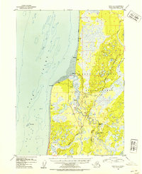
1952 Map of Kenai B-4
USGS Topo · Published 1954About this map
Kasilof and its surrounding homesteads define this coastal stretch of the Kenai Peninsula in the early 1950s. The settlement pattern follows the Kasilof River and the shoreline of Cook Inlet, where small clusters of Cabins and isolated Cabin labels mark the early residential development of Cohoe and Kalifonsky. Transport in the region relies heavily on the Sterling Highway and the Kalifonsky Beach Road, while the Kasilof Landing Strip provides critical aerial access to this developing frontier.
Find a feature on this map
29 named features on this map. Tap any name to fly to it.
Don’t see what you’re looking for? This feature index may not catch every label — zoom into the map to look around manually.
Map Details
Editions of this 1952 Kenai B-4 Map
3 editions found

Other maps of this area

1944 · Kenai
USGS Topo · 1:250,000

1950 · Kenai
USGS Topo · 1:250,000

1950 · Kenai C-3
USGS Topo · 1:63,360

1950 · Kenai B-3
USGS Topo · 1:63,360

1951 · Kenai A-5
USGS Topo · 1:63,360

1951 · Kenai A-3
USGS Topo · 1:63,360

1951 · Kenai C-4
USGS Topo · 1:63,360

1951 · Kenai C-3
USGS Topo · 1:63,360

1951 · Kenai B-4
USGS Topo · 1:63,360

1951 · Kenai A-4
USGS Topo · 1:63,360