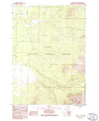
1986 Map of Kenai C-1 NE
USGS Topo · Published 1986About this map
Kenai National Wildlife Refuge and the surrounding protected lands dominate this landscape on the Kenai Peninsula in the mid-1980s. The region is characterized by a complex network of wetlands and drainage patterns, most notably the winding course of the Chickaloon River and its tributary, Thurman Creek. Evidence of human accessibility is limited to a solitary Landing Strip and a marked 4wd track, suggesting a reliance on aerial and specialized off-road transport for backcountry navigation. The interplay of the Kenai Wilderness and the Chugach National Forest Boundary reflects the formalization of Alaskan conservation units during this era, preserving a wilderness area defined by its intricate hydrological features and absence of established settlements.
Find a feature on this map
9 named features on this map. Tap any name to fly to it.
Don’t see what you’re looking for? This feature index may not catch every label — zoom into the map to look around manually.
Map Details
Editions of this 1986 Kenai C-1 NE Map
This is the sole edition of this map. No revisions or reprints were ever made.
Other maps of this area

1944 · Kenai
USGS Topo · 1:250,000

1950 · Kenai
USGS Topo · 1:250,000

1951 · Seward
USGS Topo · 1:250,000

1951 · Kenai C-1
USGS Topo · 1:63,360

1951 · Kenai D-1
USGS Topo · 1:63,360

1951 · Seward C-8
USGS Topo · 1:63,360

1951 · Seward D-8
USGS Topo · 1:63,360

1952 · Kenai C-1
USGS Topo · 1:63,360

1952 · Seward D-8
USGS Topo · 1:63,360

1952 · Seward C-8
USGS Topo · 1:63,360