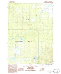
1986 Map of Kenai D-1 SE
USGS Topo · Published 1986About this map
The Chickaloon River meanders through this portion of the Kenai Peninsula, marking a landscape defined by its network of glacial lakes and marshy lowlands. This 1980s provisional survey illustrates the expansive reach of the Kenai National Wildlife Refuge, with the Kenai Wilderness Boundary bisecting the terrain to separate managed lands from protected wilderness. Named water bodies like Lonesome Lake, Moose Pasture Lake, and Trapper Joe Lake are scattered across the quadrangle, reflecting the local importance of these features for navigation and identification in an area with minimal road development. A solitary Landing Strip in the northeast quadrant suggests the reliance on bush planes for access to this interior region. The map preserves the specific geography of the Scenic Lake area and the intricate hydrology of the Kenai lowlands during the late twentieth century.
Find a feature on this map
10 named features on this map. Tap any name to fly to it.
Don’t see what you’re looking for? This feature index may not catch every label — zoom into the map to look around manually.
Map Details
Editions of this 1986 Kenai D-1 SE Map
This is the sole edition of this map. No revisions or reprints were ever made.
Other maps of this area

1944 · Kenai
USGS Topo · 1:250,000

1950 · Kenai
USGS Topo · 1:250,000

1951 · Seward
USGS Topo · 1:250,000

1951 · Kenai C-1
USGS Topo · 1:63,360

1951 · Kenai D-1
USGS Topo · 1:63,360

1951 · Seward C-8
USGS Topo · 1:63,360

1951 · Seward D-8
USGS Topo · 1:63,360

1952 · Kenai C-1
USGS Topo · 1:63,360

1952 · Seward D-8
USGS Topo · 1:63,360

1952 · Seward C-8
USGS Topo · 1:63,360