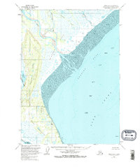
1958 Map of Kenai D-5
USGS Topo · Published 1972About this map
Cook Inlet and the Trading Bay shoreline dominate this 1958 survey, updated in the early 1970s to reflect the emerging offshore energy industry. The map documents a cluster of early marine infrastructure, including Oil Platform Spark, Oil Platform King, and Oil Platform Dolly Varden positioned within the inlet. The mainland is characterized by a complex network of glacial rivers and wetlands, where the Mc Arthur River and Chakachatna River empty into the vast Tidal Flat. Human presence on the land is sparse, marked primarily by scattered Cabin sites and a single Landing Strip near the West Foreland. Rising above the wetlands, the Kustatan Ridge provides a distinct break in the low-lying terrain, offering a geographic anchor between the Kustatan River and the coast.
Find a feature on this map
25 named features on this map. Tap any name to fly to it.
Don’t see what you’re looking for? This feature index may not catch every label — zoom into the map to look around manually.
Map Details
Editions of this 1958 Kenai D-5 Map
3 editions found

Other maps of this area

1944 · Kenai
USGS Topo · 1:250,000

1949 · Tyonek
USGS Topo · 1:250,000

1950 · Kenai
USGS Topo · 1:250,000

1950 · Kenai D-4
USGS Topo · 1:63,360

1951 · Tyonek
USGS Topo · 1:250,000

1951 · Kenai C-4
USGS Topo · 1:63,360

1952 · Kenai D-4
USGS Topo · 1:63,360

1952 · Kenai C-4
USGS Topo · 1:63,360

1958 · Tyonek A-6
USGS Topo · 1:63,360

1958 · Tyonek A-5
USGS Topo · 1:63,360