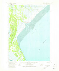
1958 Map of Kenai D-5
USGS Topo · Published 1973About this map
Industrial expansion into the waters of Cook Inlet defines this mid-century period on the Kenai Peninsula, marked by a cluster of offshore oil rigs. Deep-water structures such as Oil Platform Spark, Oil Platform King, and Oil Platform Dolly Varden are situated within Trading Bay, signaling the era's focus on marine resource extraction. The shoreline is characterized by extensive Tidal Flats and complex river deltas where the Mc Arthur River, Chakachatna River, and Middle River meet the sea.
Find a feature on this map
25 named features on this map. Tap any name to fly to it.
Don’t see what you’re looking for? This feature index may not catch every label — zoom into the map to look around manually.
Map Details
Editions of this 1958 Kenai D-5 Map
3 editions found

Other maps of this area

1944 · Kenai
USGS Topo · 1:250,000

1949 · Tyonek
USGS Topo · 1:250,000

1950 · Kenai
USGS Topo · 1:250,000

1950 · Kenai D-4
USGS Topo · 1:63,360

1951 · Tyonek
USGS Topo · 1:250,000

1951 · Kenai C-4
USGS Topo · 1:63,360

1952 · Kenai D-4
USGS Topo · 1:63,360

1952 · Kenai C-4
USGS Topo · 1:63,360

1958 · Tyonek A-6
USGS Topo · 1:63,360

1958 · Tyonek A-5
USGS Topo · 1:63,360