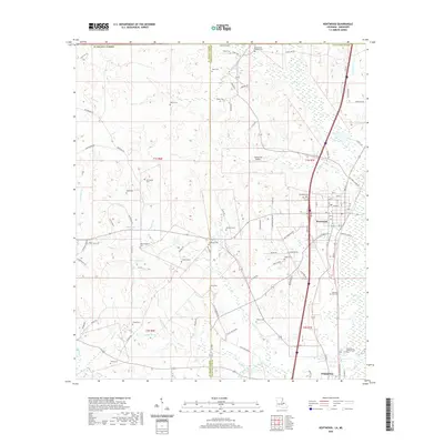
2020 Map of Kentwood
USGS Topo · Published 2020About this map
The town of Kentwood and the village of Tangipahoa anchor this 2020 landscape in the northern reach of Tangipahoa Parish. The map reveals a high density of rural burial grounds, highlighting the deep genealogical roots of the area through family and community markers such as Westmoreland Cem, Varnado Cem, and Lambert Cem. Near the southern edge, the Camp Moore Confederate Cem stands as a significant commemorative site. The terrain is defined by a network of small waterways, including Beaver Creek, Cool Creek, and the various forks of Jenny Branch. These streams cut through the parish toward the border with St. Helena Parish. Small-scale aviation is represented by the Cool Creek Airport, while the local hydrology is punctuated by features like Brabbhams Pond and Youngs Pond.
Find a feature on this map
106 named features on this map. Tap any name to fly to it.
Don’t see what you’re looking for? This feature index may not catch every label — zoom into the map to look around manually.
Map Details
Editions of this 2020 Kentwood Map
This is the sole edition of this map. No revisions or reprints were ever made.
Other maps of this area

1940 · Spring Creek
USGS Topo · 1:31,680

1940 · Roseland
USGS Topo · 1:31,680

1942 · Roseland
USGS Topo · 1:31,680

1942 · Liverpool
USGS Topo · 1:31,680

1949 · Bolivar
USGS Topo · 1:31,680

1950 · Kentwood
USGS Topo · 1:31,680

1950 · Greensburg
USGS Topo · 1:31,680

1953 · Natchez
USGS Topo · 1:250,000

1954 · Baton Rouge
USGS Topo · 1:250,000

1956 · Natchez
USGS Topo · 1:250,000