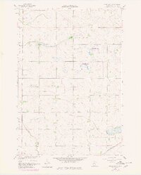
1958 Map of Kerkhoven SE
USGS Topo · Published 1980About this map
Hawk Creek meanders through the central landscape of this Chippewa County region, defining a rural territory characterized by the townships of Woods and Lone Tree. This late 1950s documentation, updated with photogrammetric revisions from the 1970s, reveals a sparse agricultural settlement pattern anchored by small-scale community landmarks. A Town Hall and School No 317 serve as primary social markers for the surrounding farmstead network, while the Sacred Heart Cem and the Great Northern railroad corridor in the southeast corner indicate the historical transportation and heritage ties of the area. Significant portions of the land are dedicated to conservation, shown as the State Wildlife Management Area, highlighting the intersection of managed natural spaces and working farmland during this period of Minnesota's mid-century development.
Find a feature on this map
9 named features on this map. Tap any name to fly to it.
Don’t see what you’re looking for? This feature index may not catch every label — zoom into the map to look around manually.
Map Details
Editions of this 1958 Kerkhoven SE Map
3 editions found
Other maps of this area

1953 · New Ulm
USGS Topo · 1:250,000

1953 · Saint Cloud
USGS Topo · 1:250,000

1957 · Saint Cloud
USGS Topo · 1:250,000

1957 · New Ulm
USGS Topo · 1:250,000

1958 · New Ulm
USGS Topo · 1:250,000

1958 · Saint Cloud
USGS Topo · 1:250,000

1958 · Murdock
USGS Topo · 1:24,000

1958 · Kerkhoven SE
USGS Topo · 1:24,000

1958 · Kerkhoven
USGS Topo · 1:24,000

1958 · Kerkhoven SW
USGS Topo · 1:24,000