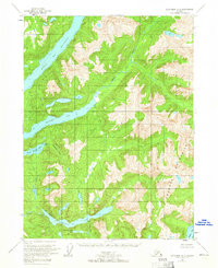
1955 Map of Ketchikan A-2
USGS Topo · Published 1965About this map
Boca De Quadra and its deep fjord-like inlets define this coastal wilderness within the Tongass National Forest. The 1955 field survey captures a landscape shaped by glacial waters and short, rapid rivers, most notably the Marten River and Red River which feed into the sheltered Marten Arm. Industrial footprints are sparse but significant, including an isolated Mine and a Gaging Sta near the shoreline.
Find a feature on this map
20 named features on this map. Tap any name to fly to it.
Don’t see what you’re looking for? This feature index may not catch every label — zoom into the map to look around manually.
Map Details
Editions of this 1955 Ketchikan A-2 Map
3 editions found
Other maps of this area

1951 · Prince Rupert
USGS Topo · 1:250,000

1952 · Ketchikan
USGS Topo · 1:250,000

1955 · Ketchikan A-2
USGS Topo · 1:63,360

1955 · Prince Rupert D-3
USGS Topo · 1:63,360

1955 · Ketchikan A-1
USGS Topo · 1:63,360

1955 · Ketchikan B-2
USGS Topo · 1:63,360

1955 · Ketchikan B-1
USGS Topo · 1:63,360

1955 · Ketchikan A-3
USGS Topo · 1:63,360

1955 · Prince Rupert D-2
USGS Topo · 1:63,360

1955 · Ketchikan B-3
USGS Topo · 1:63,360